


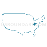
Logan, Mingo, Wyoming & McDowell Counties PUMA, West Virginia
About
Outline

Summary
| Unique Area Identifier | 194385 |
| Name | Logan, Mingo, Wyoming & McDowell Counties PUMA |
| State | West Virginia |
| Area (square miles) | 1,916.30 |
| Land Area (square miles) | 1,909.75 |
| Water Area (square miles) | 6.55 |
| % of Land Area | 99.66 |
| % of Water Area | 0.34 |
| Latitude of the Internal Point | 37.64261100 |
| Longtitude of the Internal Point | -81.79101940 |
Maps

Graphs
Select a template below for downloading or customizing gragh for Logan, Mingo, Wyoming & McDowell Counties PUMA, West Virginia


Neighbors
Neighoring Public Use Microdata Area (by Name) Neighboring Public Use Microdata Area on the Map
- Big Sandy Area Development District PUMA, KY
- Cabell, Wayne & Mason Counties--Huntington City PUMA, WV
- LENOWISCO & Cumberland Plateau Planning District Commissions PUMA, VA
- Putnam, Boone & Lincoln Counties PUMA, WV
- Raleigh, Mercer & Fayette Counties PUMA, WV
Top 10 Neighboring County (by Population) Neighboring County on the Map
- Raleigh County, WV (78,859)
- Pike County, KY (65,024)
- Mercer County, WV (62,264)
- Tazewell County, VA (45,078)
- Wayne County, WV (42,481)
- Logan County, WV (36,743)
- Mingo County, WV (26,839)
- Boone County, WV (24,629)
- Buchanan County, VA (24,098)
- Wyoming County, WV (23,796)
Top 10 Neighboring County Subdivision (by Population) Neighboring County Subdivision on the Map
- District 2, Raleigh County, WV (25,106)
- District 1, Raleigh County, WV (24,419)
- District III, Mercer County, WV (21,345)
- District I, Mercer County, WV (18,572)
- Eastern district, Logan County, WV (13,839)
- Western district, Logan County, WV (12,320)
- Central district, Logan County, WV (10,584)
- Northern district, Tazewell County, VA (9,243)
- District 3, Wyoming County, WV (8,522)
- Stonewall district, Wayne County, WV (8,100)
Top 10 Neighboring Place (by Population) Neighboring Place on the Map
- Williamson city, WV (3,191)
- Welch city, WV (2,406)
- Logan city, WV (1,779)
- Mount Gay-Shamrock CDP, WV (1,779)
- Mallory CDP, WV (1,654)
- Mullens city, WV (1,559)
- Oceana town, WV (1,394)
- Chapmanville town, WV (1,256)
- Gilbert Creek CDP, WV (1,090)
- Gary city, WV (968)
Top 10 Neighboring Unified School District (by Population) Neighboring Unified School District on the Map
- Raleigh County School District, WV (78,859)
- Mercer County School District, WV (62,264)
- Pike County School District, KY (58,483)
- Tazewell County Public Schools, VA (45,078)
- Wayne County School District, WV (42,481)
- Logan County School District, WV (36,743)
- Mingo County School District, WV (26,839)
- Boone County School District, WV (24,629)
- Buchanan County Public Schools, VA (24,098)
- Wyoming County School District, WV (23,796)
Top 10 Neighboring State Legislative District Lower Chamber (by Population) Neighboring State Legislative District Lower Chamber on the Map
- State House District 27, WV (88,267)
- State House District 19, WV (72,453)
- State House District 3, VA (66,212)
- State House District 97, KY (40,179)
- State House District 93, KY (38,421)
- State House District 17, WV (34,820)
- State House District 22, WV (33,043)
- State House District 20, WV (17,527)
- State House District 18, WV (17,238)
- State House District 24, WV (17,083)
Top 10 Neighboring State Legislative District Upper Chamber (by Population) Neighboring State Legislative District Upper Chamber on the Map
- State Senate District 38, VA (175,805)
- State Senate District 31, KY (101,309)
- State Senate District 9, WV (99,759)
- State Senate District 7, WV (99,397)
- State Senate District 6, WV (93,502)
Top 10 Neighboring 111th Congressional District (by Population) Neighboring 111th Congressional District on the Map
- Congressional District 5, KY (670,051)
- Congressional District 9, VA (656,200)
- Congressional District 3, WV (588,817)
Top 10 Neighboring Census Tract (by Population) Neighboring Census Tract on the Map
- Census Tract 9561.01, Logan County, WV (6,976)
- Census Tract 203, Tazewell County, VA (6,701)
- Census Tract 9, Raleigh County, WV (5,854)
- Census Tract 11, Raleigh County, WV (5,649)
- Census Tract 101, Buchanan County, VA (5,163)
- Census Tract 31, Wyoming County, WV (5,093)
- Census Tract 9566, Logan County, WV (5,074)
- Census Tract 9568, Logan County, WV (5,018)
- Census Tract 32, Wyoming County, WV (4,911)
- Census Tract 9545.04, McDowell County, WV (4,876)
Top 10 Neighboring 5-Digit ZIP Code Tabulation Area (by Population) Neighboring 5-Digit ZIP Code Tabulation Area on the Map
- 25508, WV (9,837)
- 24605, VA (9,301)
- 24614, VA (8,061)
- 25661, WV (6,837)
- 25670, WV (5,829)
- 25601, WV (5,206)
- 24801, WV (3,858)
- 41514, KY (3,491)
- 25524, WV (3,486)
- 25674, WV (3,202)